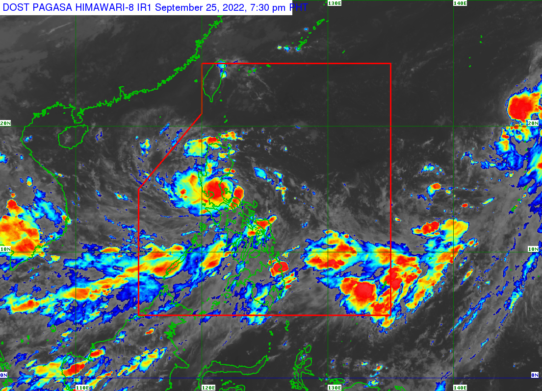
Super Typhoon Karding slightly weakened as it made landfall in Aurora, PAGASA said.
The center of the eye of Super Typhoon KARDING was spotted over the coastal waters of General Nakar, Quezon.
According to its 8 p.m. bulletin, Karding has maximum sustained winds of 185 km/h near the center, with gustiness of up to 255 km/h.
It is currently moving westward at 20 km/h. Strong to typhoon-force winds extend outwards up to 290 km from the center.
PAGASA also released the updated Tropical Cyclone Wind Signals (TCWS):
TCWS No. 5
>Wind threat: Typhoon-force winds
>Warning lead time: 12 hours
>Potential impacts of winds: Extreme threat to life and property
LUZON:
Polillo Islands, the extreme northern portion of Quezon (the northern and central portions of General Nakar, the northeastern portion of Infanta), the extreme southern portion of Aurora (Dingalan), the extreme southern portion of Nueva Ecija (General Tinio, City of Gapan, Peñaranda, San Isidro, Cabiao), Pampanga (Arayat, Candaba, Santa Ana, San Luis), the eastern and central portions of Bulacan (San Rafael, Angat, Norzagaray, Doña Remedios Trinidad, San Ildefonso, San Miguel), and the extreme northern portion of Rizal (Rodriguez), the eastern portion of Pampanga (Candaba, Arayat)
TCWS No. 4
>Wind threat: Typhoon-force winds
>Warning lead time: 12 hours
>Potential impacts of winds: Significant to severe threat to life and property
LUZON:
Calaguas Islands, the central and southern portion of Nueva Ecija (Cuyapo, Nampicuan, Guimba, Licab, Zaragoza, San Antonio, San Leonardo, Jaen, Santa Rosa, Palayan City, Gabaldon, Laur, Cabanatuan City, Aliaga, Quezon, Santo Domingo, Talavera, Llanera, General Mamerto Natividad, Rizal, Bongabon, Talugtug, Science City of Muñoz), the northern portion of Metro Manila (Marikina, Caloocan, Malabon, Navotas, Valenzuela, and Quezon City), Tarlac, the rest of Pampanga, the rest of Bulacan, Zambales, the northern portion of Bataan (Dinalupihan, Hermosa, Morong, Orani, Samal, Abucay), the southern portion of Pangasinan (Bautista, Alcala, Bayambang, Mangatarem, Urbiztondo, Aguilar, Bugallon, Infanta, Dasol, Burgos, Mabini, Labrador), and the extreme northern portion of Laguna (Famy, Siniloan, Santa Maria, Pangil)
TCWS No. 3
>Wind threat: Storm-force winds
>Warning lead time: 18 hours
>Potential impacts of winds: Moderate to significant threat to life and property
LUZON:
The central portion of Aurora (Dipaculao), the southeastern portion of Nueva Vizcaya (Alfonso Castaneda, Dupax del Sur, Dupax del Norte), the rest of Nueva Ecija, the rest of Bataan, the rest of Pangasinan, the rest of Metro Manila, the rest of Rizal, the northern and central portions of Laguna (Mabitac, Pakil, Paete, Kalayaan, Lumban, Cavinti, Pagsanjan, Luisiana, Majayjay, Magdalena, Santa Cruz, Pila, Liliw, Nagcarlan, Victoria, Rizal, City of San Pedro, City of Biñan, City of Santa Rosa, Cabuyao City, City of Calamba, Los Baños, Bay, Calauan), the northern and central portions of Cavite (Tanza, Rosario, Noveleta, Kawit, Imus City, Bacoor City, City of Dasmariñas, Carmona, Gen. Mariano Alvarez, Silang, Amadeo, City of General Trias, Trece Martires City, Naic, Indang), the rest of the northern portion of Quezon (Infanta, Real, General Nakar, Mauban), and the northern portion of Camarines Norte (Vinzons, Paracale, Jose Panganiban, Capalonga)
TCWS No. 2
>Wind threat: Gale-force winds
>Warning lead time: 24 hours
>Potential impacts of winds: Minor to moderate threat to life and property
LUZON:
The southern portion of Isabela (Dinapigue, San Guillermo, Echague, San Agustin, Jones), Quirino, the rest of Nueva Vizcaya, Benguet, La Union, the rest of Aurora, the rest of Cavite, Batangas, the rest of Laguna, the central portions of Quezon (Calauag, Perez, Alabat, Quezon, Tagkawayan, Guinayangan, Sampaloc, Lucban, City of Tayabas, Lucena City, Pagbilao, Padre Burgos, Atimonan, Agdangan, Unisan, Plaridel, Gumaca, Lopez, Pitogo, Dolores, Candelaria, Sariaya, Tiaong, San Antonio, Macalelon, General Luna, Catanauan, Buenavista), the rest of Camarines Norte, the northern portion of Camarines Sur (Del Gallego, Ragay, Lupi, Sipocot, Libmanan, Pamplona, Pasacao, San Fernando, Pili, Minalabac, Ocampo, Tigaon, Cabusao, Magarao, Gainza, Canaman, Camaligan, Milaor, Naga City, Bombon, Calabanga, Tinambac, Siruma, Goa, Lagonoy, San Jose, Garchitorena, Presentacion, Caramoan, Sagñay), and Catanduanes
TCWS No. 1
>Wind threat: Strong winds
>Warning lead time: 36 hours
>Potential impacts of winds: Minimal to minor threat to life and property
LUZON:
The southern portion of Cagayan (Tuao, Solana, Enrile, Tuguegarao City, Iguig, Peñablanca), the rest of Isabela, the southern portion of Apayao (Conner), Kalinga, Abra, Mountain Province, Ifugao, the southern portion of Ilocos Norte (Nueva Era, Badoc, Pinili, Banna, City of Batac, Currimao, Paoay, Marcos), Ilocos Sur, the rest of Quezon, the northern portion of Occidental Mindoro (Abra de Ilog, Paluan, Mamburao, Santa Cruz) including Lubang Islands, the northern portion of Oriental Mindoro (Puerto Galera, San Teodoro, Baco, City of Calapan, Naujan, Victoria, Pola, Socorro, Pinamalayan), Marinduque, the rest of Camarines Sur, Albay, Sorsogon, Burias Island and Ticao Island
— Ronald Espartinez